Data product footprints
MSLApplies to the
MSL AN
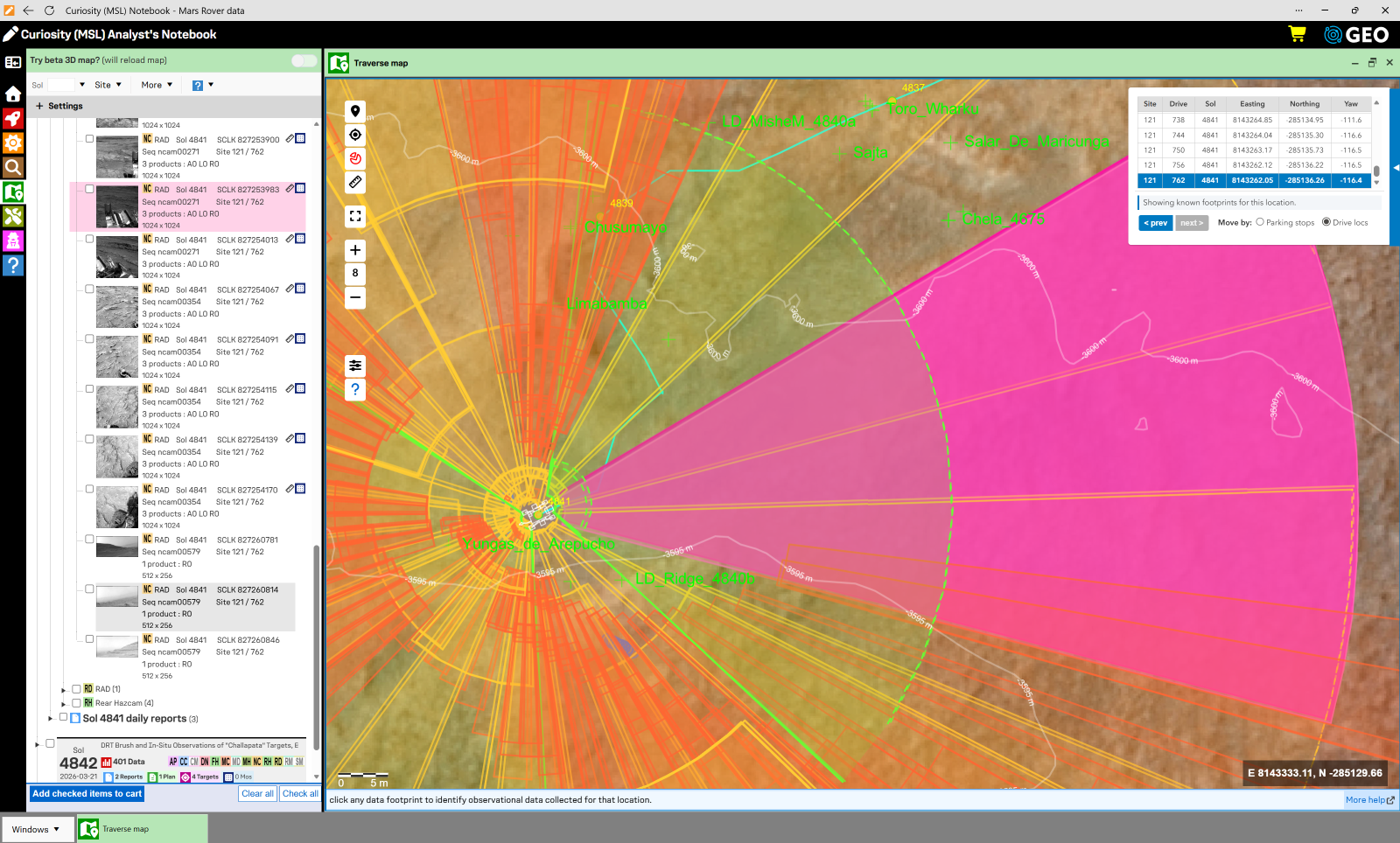
A footprint is the patch of ground that a rover image covers, drawn as an outline on a map. Footprints connect the rover's close-up view with the orbital view of the terrain it has traveled, which helps you see what the rover looked at from each stop and find the data it collected there. This deep dive explains how footprints are made and how far to trust them.
beta feature
Footprints are a beta feature. They are a good first-order approximation, reliable close to the rover and increasingly uncertain with distance, but they are just that—an approximation. We will keep refining the process and adding data and instruments.
Where footprints appear
Footprints are drawn on the Traverse map, where you can show and hide them by instrument and image eye, and on the small map in the data detail page, where the footprint of the product you are viewing is shown.
Some data products do not appear with footprints on the map. For example, images of the sky are not included. In other cases, the archived metadata may not support footprint calculations, or it might be that we still are processing those data!
How footprints are made
Footprints are calculated from metadata in each data product's PDS4 label together with the rover's position on the traverse map. The process, in broad strokes, goes like this.
- Gather the geometry. The product label records where the rover was and which way it was oriented, and where the instrument was and which way it was pointing. Instrument characteristics that are not in the label, such as the field of view, come from the instrument's Software Interface Specification (SIS) document in the archive.
- Cast rays. Using this geometry, a line of sight is traced from the camera through selected points in the image, typically its four corners.
- Intersect with the ground. Each line of sight is followed down until it meets a flat, level plane under the rover. The four points where they meet are the corners of the footprint on the ground.
- Place it on the map. The corners are rotated into the local site frame and then shifted by the rover's position on the traverse map, so the footprint lands on the basemap in the right place.
Not every product gets a footprint. Images of nothing but sky are skipped, and some products do not have the label information needed to trace the lines of sight.
Reading a footprint
- The outline is a four-sided shape. The edges nearest and farthest from the rover are drawn as arcs to reflect the perspective of the camera view. The two sides are straight lines.
- A dashed arc as the far edge means the footprint could extend farther than shown, or that the top of the image covers sky. A solid far edge means the image ends on the ground.
- Instruments with a very narrow field of view, such as ChemCam, cover so little ground that the footprint is essentially a point. These are drawn as a marker instead of an outline.
Why a footprint may not match the image
Footprint locations come with uncertainty. If a footprint does not line up with what you see in the image or on the basemap, one or more of the following is probably the reason. These are known limitations of the current approach.
| Flat ground is assumed | The ground is treated as a flat, level plane under the rover. The terrain where the rover sits may be sloped, and that tilt is not accounted for. |
| Distant topography is ignored | Hills, swales, and other terrain away from the rover are not modeled. The farther a point is from the rover, the more this matters, so the error grows toward the far edge of a footprint. The elevation data behind the basemap, derived from HiRISE, does not have the detail needed to represent the terrain at the resolution required. Higher-resolution terrain models could be made from available data in some cases, but that is beyond the scope of this effort. |
| Rover position is uncertain | The rover's location on the map has some uncertainty. See Rover locations. A footprint inherits that uncertainty and can sit slightly off from where the image really lies. |
| Sky and horizon | A camera that sees the horizon sees ground that goes on until it meets the sky. The dashed far arc shows that the footprint is cut off at an arbitrary distance. |
| Not everything is included | Sky-only images and products that lack the needed label information have no footprint, and the Notebook does not know about every product in the archive. |
Keep these in mind when you use footprints for planning or interpretation. They are a handy guide to where the rover was looking, not a surveyed boundary. When a precise location matters, rely on the image itself and the rover location data.
What's next
Footprints are currently available for Curiosity (MSL) only. We plan to add Perseverance (M20), followed by the MER rovers, along with more instruments and refinements to the method.
see also